UAV’s (drones) are becoming more widespread as a forest management tool. Common uses for drones in forestry include land inspection, photography/videography, aerial spraying of pesticides, and aerial photogrammetry. In this post I will discuss some recent experience I gained with aerial photogrammetry using a drone.
Selecting the right drone for your project and budget is important. Professional drones (i.e., enterprise level) will have more features and different payload configurations available than a drone intended for hobbyist use. Consider the type of data you will be collecting, and for what purpose. In most cases, RGB photos will be sufficient, but multispectral has it’s advantages.
I recently purchased a multispectral camera drone to delineate forest harvest areas and monitor tree health. This has been a learning experience, so I want to share a little about what drone was selected, and why. Hopefully, someone will find this information useful to help decide if a drone is the right tool for their forest operations.
My Requirements
I needed a drone that could do the following three things really well, for a reasonable price.
- To replace the cost and inconsistency of satellite imagery
- To inspect and monitor the progression of forest operations
- To monitor stand health and vigor
After speaking with several colleagues who had experience with drone mapping missions, I settled on the DJI Mavic 3M. This is an enterprise level drone with an emphasis on image quality. The payload has an RGB camera 20MP, and four multispectral sensors, 5MP each. The Mavic 3M is also RTK capable. You can find technical specifications on DJI’s website here.
Sensor Type
As previously stated, consideration for the type of sensor to purchase is important. Will you need RGB alone or a combination of RGB and Multispectral?
The Mavic 3M is considered an Enterprise Ag drone. What makes it an Ag drone is the multispectral image sensors of the camera and the ability to monitor crop indices such as NDVI in real-time or from post-processed imagery. This drone captures photos and video in standard RGB format and with the following four bands in multispectral mode – Green (G), Red (R), RE (Red Edge), and Near Infrared (NIR). Each band is exported from the processing step as a single TIF image, but can be combined into a composite image using standard GIS software such as ArcGIS Pro or QGIS.
Below is an example of NDVI with a composite image using Red and NIR bands. The darker red-orange tones signify healthy vegetation. I added the black circles to highlight recently planted pine seedlings that were visible in the image. Some of these were visible in the RGB version, however, they stand out more using NDVI. These seedlings were about 3 months old at the time of the photo.

Positional Accuracy
Accuracy can be stated in terms of relative and absolute, where relative refers to the correct sizing of objects in the output, and absolute refers to the position in relation to objects on the ground. I use the term here to mean absolute accuracy.
The Mavic 3M is equipped with an onboard GNSS GPS receiver, and DJI offers an optional RTK module upgrade for projects requiring higher overall accuracy. The RTK module is capable of centimeter-level accuracy (absolute and relative) when coupled with a high precision GNSS RTK Base, or a subscription to a local VRS service. The base and VRS service expenses are in addition to the drone itself.
I was curious if RTK correction was necessary, given the added cost. I think this needs to be determined on a use-case basis and whether the project needs the additional accuracy, or not. My current opinion is that RTK is not needed for forest imagery, since 1-3 meter absolute accuracy is commonly accepted in most forest projects. For example, when mapping stand boundaries using satellite images, or using consumer grade GPS units, the accuracy is probably no better than 1-3 meters anyway.
From what I have observed, the Mavic 3M GNSS receiver provides this level of accuracy “out-of-the-box”. However, for the additional $700 spend I recommend getting the RTK unit in case you find that you need better accuracy. You can always buy the additional equipment such as the RTK Base later on if needed.
Spatial Resolution
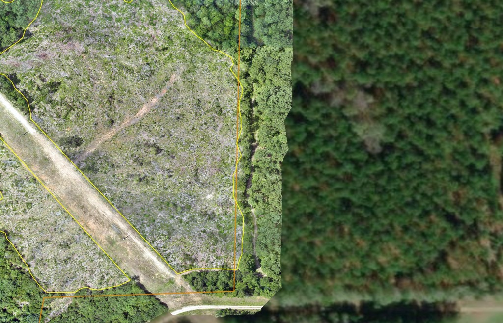
Another important feature when considering drone photography is spatial resolution. Drones are capable of higher resolution than satellite imagery. The spatial resolution is determined by the sensor properties and the flight altitude, and we can alter the GSD (ground sampling distance) by changing the altitude of flight. At flight altitudes around 250 feet AGL the Mavic 3M images are around 1 inch per pixel resolution. The following photo shows an example of the drone resolution next to ESRI World imagery resolution, which is stated to be 1 meter or less per pixel.
Summary
There are other drones on the market that I think are similar to the Mavic 3M for forestry work. Some that I compared were the Autel EVO II v3 and the DJI Phantom 4 Multispectral. In terms of cost, the Mavic 3M falls somewhere between these other two models, with the Autel drone being slightly less expensive. For a professional mapping drone with centimeter-level accuracy with RTK corrections, expect to spend between $8,000 and $10,000 for the drone and supporting hardware. There are additional expenses for the post-processing software as well.
I’m curious to know what other think on the topic of drone use in forestry, and what investments companies have made in this regard. Drop a line in the comments or send me a message.
*Photo credit by JuniperPhoton on Unsplash
Categories: Drones Geospatial Satellite Imagery Technology Investments